
- Two types of sail, the Jib and the Mainsail, and how to to it, e.g. raising a jib,..., and,
- Nautical Chart - you know a) where you are and b) avoiding problems e.g. underwater rocks,...
Types of Sail
1. Jib From Wikipedia, the free encyclopedia
A jib is a triangular staysail that sets ahead of the foremast of a sailing vessel. Its tack is fixed to the bowsprit, to the bow, or to the deck between the bowsprit and the foremost mast. Jibs and spinnakers are the two main types of headsails on a modern boat.
Modern Yachts and Small Craft
 |
A jib, left, compared to a genoa, right.
The foretriangle is outlined in red.
|
On boats with only one jib, it is common for the clew of the jib to be further aft than the mast, meaning the jib and mainsail overlap. An overlapping jib is called a genoa jib or simply a genoa (see illustration). These are efficiently used when reaching more broadly than a close reach. Alternatively, a boat may carry smaller jibs, to compensate aerodynamics when the main sail is reefed; these more rugged sails are called storm jibs or spitfires.
On a boat with two staysails the inner sail is called the staysail, and the outer (foremost) is called the jib. This combination of two staysails is called a cutter rig (or a yankee pair) and a boat with one mast rigged with two staysails and a mainsail is called a cutter.
On cruising yachts with more than one jib, it is common for the innermost jib to be self-tacking, either by using a boom along the foot of the sail, or by cleating the jib sheet to a track, or both. On other cruising yachts, and nearly all racing sailboats, the jib needs to be worked when tacking. On these yachts, there are two sheets attached to the clew of the jib. As the yacht comes head to wind during a tack, the active sheet is released, and the other sheet (the lazy sheet) on the other side of the boat is pulled in. This sheet becomes the new active sheet until the next tack.
Traditional Vessels
 |
The barque Alexander von Humboldt, with four jibs set
and a fifth furled on the bowsprit
|
A large square-rigged ship typically has four jibs (though vessels with more or fewer exist). From forward to aft, these sails are called:
- Flying jib
- Outer jib
- Inner jib
- Fore (topmast) staysail
See the original article:
Jib From Wikipedia, the free encyclopedia
2. Genoa From Wikipedia, the free encyclopedia
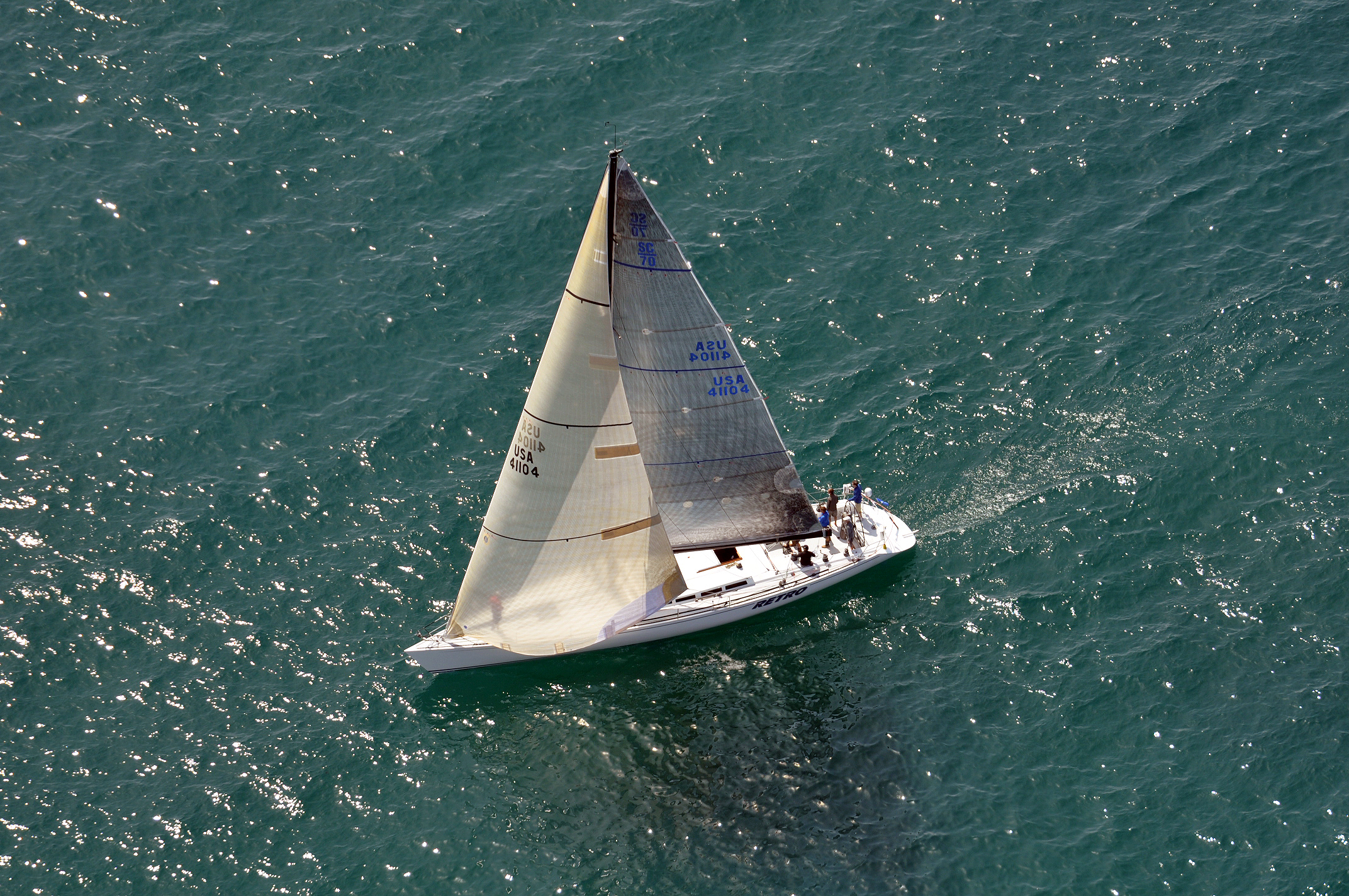 |
SC70 RETRO's genoa overlaps the main sail and the mast
|
The genoa or genny was originally referred to as an 'overlapping jib' and later as a Genoa jib, being named after the city of Genoa as explained below. It is a type of large jib or staysail that overlaps the main sail, sometimes eliminating it. It is used on single-masted sloops and twin-masted boats such as yawls and ketches. Its larger surface area increases the speed of the craft in light to moderate winds; in high wind conditions a smaller jib is usually substituted, and downwind a spinnaker may be used. The feature that distinguishes a genoa from a working jib is that the former extends past the mast, overlapping the mainsail when viewed from the side.
Definition
|
A jib, left, compared to a roughly 110% genoa, right.
The foretriangle is outlined in red.
|
Genoas are categorized by a percentage representing their area relative to the 100% foretriangle. Sail racing classes often specify a limit to genoa size. Genoas are classified by their size; a modern number 1 genoa would typically be approximately 155%, but historically number 1 genoas have been as large as 180%. Number 2 genoas are generally in the range of 125%-140%. Working jibs are also defined by the same measure, typically 100% or less of the foretriangle. Under Performance Handicap Racing Fleet rules, most boats are allowed 155% genoas without a penalty.
Handling Issues
Maximizing the sail area can cause more difficult handling. It may be harder to tack a genoa than a jib, since the overlapping area can become tangled with the shrouds and/or mast unless carefully tended during the tack. Genoas are very popular in some racing classes, since they count only the foretriangle area when calculating foresail size; a genoa allows a significant increase in actual sail area within the calculated sail area. In boats where sail restrictions are not applicable, genoas of 180% overlap can be found, although those over 150% are not often seen, since the additional area is shadowed by the mainsail when close hauled and generates diminishing returns in terms of power per actual sail area.
The Gennaker
The gennaker has been around for several decades now, and as the name suggests, it is a hybrid between a genoa and an asymmetrical spinnaker. A brand name of North Sails, the gennaker started as a cruising sail based on the Code 0 spinnakers used on racing boats. Gennakers and similar code 0 variants offered by other makers are even larger than genoas (200% overlaps are not uncommon), and they have a much greater camber for generating larger amounts of lift when reaching. Flat-cut gennakers can be effective for angles as low as 60–70 degrees. Spinnakers perform much better when running because the main sail blocks the wind of gennaker above 135–150 degrees.
History
The genoa jib was invented and first used by the well-known Italian sailor and sailmaker Raimondo Panario. It was first used on the 6mR "Cora IV" built in 1925, owner G. Roggero, during the 1926 Genoa's winter races, hence its name "genoa jib" (Coppa del Tirrenio). This was a huge success since Cora IV unquestionably was the winner. Invited to Denmark for the Copenhagen's International Races which he brilliantly won too, Panario was congratulated by the King Christian X who called him "the first skipper of Europe." The famous Swedish sailor and shipowner Sven Salén (1890–1969) first used the genoa on his 6 m R-yacht "May-Be" by the end of 1926. He successfully used it during the Scandinavian Gold Cup's races of 1927 in Oyster Bay (US) which he won and made the claim he was the genoa jib's inventor though he truly was not.
A similar type of jib was in use for centuries by the fishermen in the Netherlands with their Botter type ships. The fishermen relied on the combination of a large jib while fishing so the mainsail could remain unused. After fishing the fisherman's jib helped to get the fish to markets fast.
A correct explanation of the interaction between jib and mainsail was published by aerodynamicist and yachtsman Arvel Gentry in 1981, and "is much more complicated than the old theories imply". This states that the widely believed explanation of the slot effect is "completely wrong" and shows that this is not due to the venturi effect (or "valve effect" to use Curry's term) accelerating the air in the slot. Instead it is shown that the air in the slot is slowed down and its pressure increased reducing the tendency of the mainsail to stall, that the mainsail reduces the air pressure on the lee side of the jib accelerating that airflow, and that the mainsail increases the angle at which the air meets the luff of the jib, allowing the boat to point higher. Gentry points out that proper understanding of sail interaction allows better sail trimming.
See the original article:
Genoa From Wikipedia, the free encyclopedia
3. Mainsail From Wikipedia, the free encyclopedia
 |
The mainsail of this cutter is indicated in red
|
On a square rigged vessel, it is the lowest and largest sail on the main mast.
On a fore-and-aft rigged vessel, it is the lowest and largest and often the only sail rigged aft of the main mast, and is controlled along its foot by a spar known as the boom. A sail rigged in this position without a boom is generally called a trysail, and is used in extremely heavy weather.
The modern Bermuda rig uses a triangular mainsail as the only sail aft of the mast, closely coordinated with a jib for sailing upwind. A large overlapping jib or genoa is often larger than the mainsail. In downwind conditions (with the wind behind the boat) a spinnaker replaces the jib.
Most modern mainsails are "full-batten" mainsails. Battens enable the mainsail to project farther away from the mast. However, there is some cost associated with the battens themselves, "batten pockets" need to be sewn into the sail, and "batten cars" are needed to allow the sail to be raised and lowered.
Traditional fore-and-aft rigs used a four-sided gaff rigged mainsail, sometimes setting a gaff topsail above it.
A roll mainsail is furled by being rolled within (or around) the mast or boom.
Before Nathanael Greene Herreshoff invention of sail tracks and slides in the 1880s, mainsails were limited in height. Traditional mainsails were held against the mast by hoops that went the full way around the mast. This meant a traditional mainsail could be raised no higher than the first point a rope or wire was required to keep the mast upright.
See the original article:
Mainsail From Wikipedia, the free encyclopedia
4. Spinnaker From Wikipedia, the free encyclopedia
SSTattler: It is hard to handle a spinnaker for the beginner — get training by an expert to “fly the chute” and know the “broaching”, “death roll”, …, etc.
 |
Bear of Britain, a Farr 52 with masthead
spinnaker in front of Calshot Spit
|
The spinnaker is often called a kite, or a chute (as in cruising chute) because it somewhat resembles a parachute in both construction and appearance. This should not be confused with the spinnaker chute which is a hull fitting sometimes used for launching and recovering the spinnaker. The first boat to carry this sail was the Sphinx.
Operation
A well designed spinnaker will have taut leading edges when filled; leading edges that curl in will both reduce the lift and risk a collapse of the spinnaker. A well designed spinnaker will also have a smooth curve when filled, with no bubbles or depressions caused by inconsistent stretching of the sail fabric. Any deviations from a smooth curve will cause the airflow over the leeward side of the sail to separate causing a reduction in lift and reduced performance.
When running downwind in heavy weather or when hit by a gust, with or without a spinnaker, there may be a tendency for a roll of increasing amplitude to build up, known as the death roll. It has been shown that this is due to aerodynamic instability of bermuda rigs when running, which can be aggravated by gusts, waves, mainsail twist, daggerboard etc. too far down, hull form, and the sailing equivalent of pilot-induced oscillation. Excessive heel leads to loss of rudder effectiveness resulting in the boat slewing round uncontrollably in the direction opposite to the direction of heel. This is known as broaching. Aerodynamic instability when running can be countered by easing the pole forward slightly and over-sheeting the spinnaker somewhat to stop it swinging from side to side, by reducing mainsail twist using the boom vang, and by skillfully trimming the mainsheet. Luffing carefully onto a broad reach may help to retain control, as can moving everyone's weight as far aft as possible. Reducing sail should be considered.
Types of Spinnakers
There are two main categories of spinnakers, symmetric and asymmetric depending on whether a plane of symmetry exists for that particular sail. Asymmetric spinnakers operate more like a jib, generating lift from the side, rather than the top like a symmetric spinnaker. This makes asymmetrics a better choice on reaching courses than symmetric spinnakers, which excel when running. While a fully equipped racing boat might have a number of spinnakers, both symmetric and asymmetric, to cover all courses and wind conditions, cruising boats almost always use an asymmetric, due to the broader application and easier handling afforded by the asymmetric.
Symmetric Spinnakers
 |
420 class dinghies with symmetric spinnakers.
|
The symmetric one is the most classic type, running symmetrical alongside the boat controlled by lines known as a sheet and a guy running from the lower two corners of the sail. The windward line, or guy, is attached to the corner called the tack of the sail, and is stabilized by a spinnaker pole. The leeward (downwind) line is called the sheet. It attaches to the clew of the spinnaker and is used to control the shape of the sail. The spinnaker pole must be moved in each gybe, and is quite difficult for beginners to use. However, it can be sailed in all downwind wind directions.
Symmetric spinnakers when sailing across the wind (reaching) develop most of their lift on the forward quarter, where the airflow remains attached. When correctly set for reaching, the leading edges of a symmetric spinnaker should be nearly parallel to the wind, so the flow of air over the leading edge remains attached. When reaching, the sail camber allows only some attached flow over the leeward side of the spinnaker. On running the spinnaker is angled for maximum drag, with the spinnaker pole at right angles to the apparent wind. The symmetric spinnaker also requires care when packing, since the three corners must be available on the top of the packing.
Asymmetric Spinnakers
 |
RS K6 keelboat with an asymmetric spinnaker
on a retracting bowsprit.
|
Since the 1960s many faster sailing craft, starting with catamaran classes, had discovered that it is faster to sail downwind on a series of broad reaches with efficient airflow across the sail rather than directly downwind with the sails stalled. This technique had developed to the extent that in bar conversation at the end of one season Andrew Buckland observed that the 18s had sailed all season without pulling the spinnaker pole back from the forestay and that all the systems could be simplified by eliminating the pole and setting the spinnaker from a fixed (but often retractable) bowsprit. The concept quickly evolved to a sail with a loose luff much more like a conventional spinnaker than the old jib style asymmetric sails. Julian Bethwaite was the first to rig and sail a boat with one the next season, followed shortly by Andrew Buckland. The first modern offshore sailboats to incorporate a retractable bow sprit and an asymmetric spinnaker were J/Boats - specifically, the J/105. . Today, J/Boats have built the world's largest fleets of asymmetric spinnaker sailboats - over 3,000 today.
The concept has spread rapidly through the sailing world. The tack of the sail may be attached at the bow like a genoa but is frequently mounted on a bowsprit, often a retracting one. If the spinnaker is mounted to a special bowsprit, it is often possible to fly the spinnaker and the jib at the same time; if not, then the spinnaker will be shadowed by the jib, and the jib should be furled when the spinnaker is in use.
The asymmetric has two sheets, very much like a jib, but is not attached to the forestay along the length of the luff, but only at the corners. Unlike a spinnaker, the asymmetric does not require a spinnaker pole, since it is fixed to the bow or bowsprit. The asymmetric is very easy to gybe since it only requires releasing one sheet and pulling in the other one, passing the sail in front of the forestay. Asymmetrics are less suited to sailing directly downwind than spinnakers, and so instead the boat will often sail a zig-zag course downwind, gybing at the corners. An asymmetric spinnaker is particularly effective on fast planing dinghies as their speed generates an apparent wind on the bow allowing them to sail more directly downwind. It is also particularly useful in cruising yachts in the form of a cruising spinnaker or cruising chute, where the ease of handling is important. Various types of asymmetrics exist, and a common nomenclature classifies them by code from 0 to 6. Codes 1, 3, and 5 are reaching sails, and codes 2, 4, and 6 are running sails; the code 0 is a hybrid of genoa and spinnaker, designed to work like a genoa but classified under racing rules as a spinnaker.
- Code 0 The code 0 asymmetric is a tight reaching sail, the most upwind capable of the asymmetrics. The luff is as straight as possible, and the sail is flatter than other spinnakers. Due to the flatness of the code 0, it is usually made with a wire luff for strength, and of a heavier, less stretchy fabric than normal for a spinnaker. Due to the tight luff and flat cut, the code 0 can be fitted for roller furling.
- Code 1 The code 1 is a light air reaching sail, where the apparent wind angles at low speeds has a significant effect to create angles of less than 90 degrees.
- Code 2 The code 2 is a medium air running sail, used for apparent wind angles over 90 degrees.
- Code 3 The code 3 is a medium air reaching sail, used for apparent wind angles near 90 degrees.
- Code 4 The code 4 is a heavy air running sail, used in the heaviest winds normally expected.
- Code 5 The code 5 is a heavy air reaching sail, used in the heaviest winds normally expected.
- Code 6 The code 6 is a storm sail, for running in storm conditions.
Cruising Chutes
A cruising chute is a form of asymmetric spinnaker used by cruising yachts and designed for easy use when short handed. Two sheets are used, with the tack line eased by a foot or so before gybing. Alternatively only one sheet is used, with the sail snuffed before a gybe.
Flying the Spinnaker
Since they will only be used on certain points of sail, raising and lowering the spinnaker is a task that is often performed while under sail. Due to the size of spinnakers (the spinnaker is often double or more the size of the mainsail) this can be a difficult operation, since the sail will immediately catch the wind.
Rigging the Symmetric Spinnaker
Typically the symmetric spinnaker is packed in its own bag, called a turtle, with the three corners on top for ready access. The clews (lower corners) are controlled by lines called sheets. The sheets are run in front (outside) of the forestay and lead to the back of the boat. The head (top corner) is attached to the spinnaker halyard, which is used to raise the sail up the mast.
Symmetric spinnakers have the windward clew secured to a spinnaker pole. The pole is attached to the mast and holds the windward edge of the sail in position. Lines that control the spinnaker pole are called guys. The spinnaker pole may be allowed to raise and lower with the force of the wind, or it may have lines attached to it to raise (the topping lift) and lower (the foreguy or downhaul) the angle of the pole. If these lines are used, they are generally set up before setting sail, and left in place even when the spinnaker is stowed.
Since spinnakers are downwind sails, they are never tacked, they are only jibed. When jibing a symmetric, the pole is removed from one corner and attached to the opposite corner. This corner now becomes the windward corner. There are two ways this is done. Generally on smaller boats, an end-for-end jibe is accomplished by disconnecting the pole at the mast-end and connecting the mast end to the opposite side of the sail. The old sail end is disconnected and then attached to the mast. This prevents the pole from getting loose during the procedure and allows the use of only two control lines that alternate as sheet and guy (more on this below). End-for-end jibing requires a pole with identical fittings at either end. Larger boats do a dip-pole gybe (jibe) in which the pole remains attached to the mast and the outer end is lowered until it can clear the head-stay and is then raised back up on the other side of the boat to the proper height with the topping lift. The guys are adjusted as before to set the sail angle on the new course. Dip-pole jibing can use a pole with one mast end and one sail end.
Smaller boats tend to use only one line on each clew (a combination guy and sheet). The windward line that runs through the jaw of the spinnaker pole is referred to as the guy (as opposed to foreguy) and the one on the free-flying corner is referred to as the sheet. During a jibe, these roles and thus the names are reversed. Larger boats may choose to use both a sheet & guy on each corner, with the guy being a heavier line. Having 2 sets of lines will makes the jibe easier as the kite is flown by the two sheets while the crew at the bow and at the mast are removing one guy from the pole and attaching it to the other with no tension on them.
Retrieving the spinnaker is a multi-step process, and the take-down depends on wind position. First, the windward corner is detached from the spinnaker pole and the guy is released. This step is referred to as blowing the guy. This allows the spinnaker to collapse into the shadow of the mainsail, where the foot is gathered by a crew member. The halyard is then lowered, and a crew member gathers the sail and stuffs it carefully into the turtle, corners out, and ready for the next deployment. There are, however many other ways to retrieve the spinnaker depending on the conditions and intent. It may or may not go into a turtle. It may be pulled back into the cockpit & then down below to be repacked for the next hoist or be pulled in a foredeck hatch & left free for the next hoist.
Rigging the Asymmetric Spinnaker
Like the symmetric, the Asymmetrical spinnaker is often stored in a turtle, with the corners on top for easy access. While a symmetric spinnaker is flown with a "guy" and a "sheet", an asymmetric spinnaker is flown with a tackline and a "sheet." The tack attaches to the bow or (often retractable) bowsprit, and the two sheets attach to the clew. The head of the sail is attached to the spinnaker halyard, which is used to raise the sail. The sheets are passed to either side of the forestay, attached to the clew; they may be passed forward of the luff of the asymmetric, or aft of the luff of the asymmetric, between the tack line and the forestay. The sheet on the downwind (lee) side of the hull is used to trim the sail, and the opposite sheet is left slack. Often a tack line is used at leading edge to provide adjustable tension on the luff of the spinnaker. To keep the tack near the centerline of the boat, it may be attached to the forestay with a sliding collar (often riding over the furled jib on parrel beads, tacker or similar device) adjustable with a down haul, or tack line . This allows the tack to slide up and down the forestay to adjust the luff tension. On racing boats, the tack of the asymmetric is often rigged to a retractable bowsprit, which increases the foretriangle area and prevents interference with the jib. As this trend becomes more popular in racing boats, it may result in similar adaptations to cruising boats as well.
Jibing with the asymmetric is much less complex than the symmetric, due to the lack of the spinnaker pole. Much like a jib, all that is required is to change sheets. However, since the asymmetric still flies in front of the forestay, the operation is reversed. The loaded sheet is slackened, and the opposite (lazy)sheet is pulled in, which allows the sail to pass around in front of the forestay, and then be sheeted in on the new lee side of the boat.
Retrieving the asymmetric is similar to the process for the symmetric. The sheets are released, allowing the sail to collapse to the front of the boat. The foot of the sail is then gathered, and the halyard released and the head of the sail lowered, where it is packed into the turtle.
Dousing Socks
The dousing sock, "spinnaker sleeve", snuffer, or just sock, is a device used to make deploying and retrieving the spinnaker a much easier task. The sock is a long fabric tube with a ring in one end to hold it open. Since the spinnaker is stored in the sock, the first step is to set up the sock. Two lines are attached to the sock; one is attached to a bridle on the ring, for pulling the sock down, and one is up the inside, from the ring, through the top, and back down, for raising the sock; these lines may be two ends of the same line, to form a loop. The head of the spinnaker is attached the top of the sock and the ring runs down to the tack. The resulting bundle is stuffed into the spinnaker bag. The top of the sock will have provisions for attaching to the spinnaker halyard.
The spinnaker is raised as normal, but with the sock in place the spinnaker is unable to catch the wind. Once the spinnaker is raised and the guys are ready to set, the sock is raised, releasing the spinnaker. The sock remains bundled up at the head of the sail while the spinnaker is deployed. To retrieve the spinnaker, the sheet or the tack is released and the sock is pulled down, gathering the sail. The halyard is then dropped and the sail may be packed away.
Spinnaker Chute
A spinnaker chute is usually a tube or aperture in the deck close to the forestay, for the launching and recovery of the spinnaker. They are most commonly found on modern dinghy designs, and updated older classes. To allow recovery of the spinnaker into the chute, one or more recovery patches are fitted to the spinnaker, to which the tail of the spinnaker halyard is attached or passed through. The spinnaker and its halyard thus form a continuous loop, passing through the chute.
If the spinnaker chute penetrates the hull and is required to be watertight, it takes the form of a hard tube sealed to the hull at both ends. If a watertight arrangement is not required, a cloth tube may be used to contain the lowered spinnaker. Various types of spinnakers, can be used with it. Asymmetrical spinnaker s are often paired with chutes.
Etymology
Some dictionaries suggest that the origin of the word could be traced to the first boat to commonly fly a spinnaker, a yacht called the Sphinx, mispronounced as Spinx. The Sphinx first set her spinnaker in the Solent in 1865, and the first recorded use of the word was in 1866 in the August edition of Yachting Calendar and Review (p. 84). In addition, the term may have been influenced by the spanker, originally a gaff rigged fore-and-aft sail.
It has been pointed out, however, that the skippers of Thames sailing barges also used the term spinnaker for their jib staysails. Unlike the other, tanned sails of these boats, the spinnakers were usually of white color. It has thus been suggested that the term could be "connected with the obsolete word spoon, meaning to run before the wind (cf. spindrift)." Early usage of the verb to spoon can be traced back to the 16th century; the change from spoon to spin in the term spindrift is attributed to a local Scottish pronunciation. According to Merriam Webster's dictionary, however, spindrift derives from a local Scottish pronunciation of speen (not spoon), meaning "to drive before a strong wind."
Furthermore, references to a mid-nineteenth-century origin are problematic. In the logbook of the USS Constitution, opening "Remarks on Board Monday July 13th 1812" is the comment "From 12 to 4 AM moderate breezes and thick cloudy weather with rain at 1 AM hauled up the mainsail and set the spinnaker at ½ past 3 AM set the mainsail JTS [John T. Shubrick, Fifth Lieutenant]."
According to Merriam-Webster's etymology, the origin of the word spinnaker is simply unknown.
See the original article:
Spinnaker From Wikipedia, the free encyclopedia
Navigation & Nautical Chart
1. Navigation From Wikipedia, the free encyclopedia
 |
Table of geography, hydrography,
and navigation, from the 1728 Cyclopaedia
|
Navigation, in a broader sense, can refer to any skill or study that involves the determination of position and direction. In this sense, navigation includes orienteering and pedestrian navigation. For information about different navigation strategies that people use, visit human navigation.
History
In the European medieval period, navigation was considered part of the set of seven mechanical arts, none of which were used for long voyages across open ocean. Polynesian navigation is probably the earliest form of open ocean navigation, though it was based on memory and observation rather than on scientific methods or instruments. Early Pacific Polynesians used the motion of stars, weather, the position of certain wildlife species, or the size of waves to find the path from one island to another.
Maritime navigation using scientific instruments such as the mariner's astrolabe first occurred in the Mediterranean during the Middle Ages. Although land astrolabes were invented in the Hellenistic period and existed in classical antiquity and the Islamic Golden Age, the oldest record of a sea astrolabe is that of Majorcan astronomer Ramon Llull dating from 1295. The perfectioning of this navigation instrument is attributed to Portuguese navigators during early Portuguese discoveries in the Age of Discovery. The earliest known description of how to make and use a sea astrolabe comes from Spanish cosmographer Melvin Mel Pros Cespedes's Arte de Navegar (The Art of Navigation) published in 1551, based on the principle of the archipendulum used in constructing the Egyptian pyramids.
Open-seas navigation using the astrolabe and the compass started during the Age of Discovery in the 15th century. The Portuguese began systematically exploring the Atlantic coast of Africa from 1418, under the sponsorship of Prince Henry. In 1488 Bartolomeu Dias reached the Indian Ocean by this route. In 1492 the Spanish monarchs funded Christopher Columbus's expedition to sail west to reach the Indies by crossing the Atlantic, which resulted in the Discovery of America. In 1498, a Portuguese expedition commanded by Vasco da Gama reached India by sailing around Africa, opening up direct trade with Asia. Soon, the Portuguese sailed further eastward, to the Spice Islands in 1512, landing in China one year later.
The first circumnavigation of the earth was completed in 1522 with the Magellan-Elcano expedition, a Spanish voyage of discovery led by Portuguese explorer Ferdinand Magellan and completed by Spanish navigator Juan Sebastián Elcano after the former's death in the Philippines in 1521. The fleet of seven ships sailed from Sanlúcar de Barrameda in Southern Spain in 1519, crossed the Atlantic Ocean and after several stopovers rounded the southern tip of South America. Some ships were lost, but the remaining fleet continued across the Pacific making a number of discoveries including Guam and the Philippines. By then, only two galleons were left from the original seven. The Victoria led by Elcano sailed across the Indian Ocean and north along the coast of Africa, to finally arrive in Spain in 1522, three years after its departure. The Trinidad sailed east from the Philippines, trying to find a maritime path back to the Americas, but was unsuccessful. The eastward route across the Pacific, also known as the tornaviaje (return trip) was only discovered forty years later, when Spanish cosmographer Andrés de Urdaneta sailed from the Philippines, north to parallel 39º, and hit the eastward Kuroshio Current which took its galleon across the Pacific. He arrived in Acapulco on October 8, 1565.
Etymology
1530s, from L. navigationem (nom. navigatio), from navigatus, pp. of navigare "to sail, sail over, go by sea, steer a ship," from navis "ship" and the root of agere "to drive".
Basic Concepts
Latitude
Roughly, the latitude of a place on Earth is its angular distance north or south of the equator. Latitude is usually expressed in degrees (marked with °) ranging from 0° at the Equator to 90° at the North and South poles. The latitude of the North Pole is 90° N, and the latitude of the South Pole is 90° S. Mariners calculated latitude in the Northern Hemisphere by sighting the North Star Polaris with a sextant and sight reduction tables to correct for height of eye and atmospheric refraction. The height of Polaris in degrees above the horizon is the latitude of the observer, within a degree or so.
Longitude
Similar to latitude, the longitude of a place on Earth is the angular distance east or west of the prime meridian or Greenwich meridian. Longitude is usually expressed in degrees (marked with °) ranging from 0° at the Greenwich meridian to 180° east and west. Sydney, for example, has a longitude of about 151° east. New York City has a longitude of 74° west. For most of history, mariners struggled to determine longitude. Longitude can be calculated if the precise time of a sighting is known. Lacking that, one can use a sextant to take a lunar distance (also called the lunar observation, or lunar for short) that, with a nautical almanac, can be used to calculate the time at zero longitude (see Greenwich Mean Time). Reliable marine chronometers were unavailable until the late 18th century and not affordable until the 19th century. For about a hundred years, from about 1767 until about 1850, mariners lacking a chronometer used the method of lunar distances to determine Greenwich time to find their longitude. A mariner with a chronometer could check its reading using a lunar determination of Greenwich time.
Loxodrome
In navigation, a rhumb line (or loxodrome) is a line crossing all meridians of longitude at the same angle, i.e. a path derived from a defined initial bearing. That is, upon taking an initial bearing, one proceeds along the same bearing, without changing the direction as measured relative to true or magnetic north.
Modern Technique
Most modern navigation relies primarily on positions determined electronically by receivers collecting information from satellites. Most other modern techniques rely on crossing lines of position or LOP. A line of position can refer to two different things: a line on a chart and a line between the observer and an object in real life. A bearing is a measure of the direction to an object. If the navigator measures the direction in real life, the angle can then be drawn on a nautical chart and the navigator will be on that line on the chart.
In addition to bearings, navigators also often measure distances to objects. On the chart, a distance produces a circle or arc of position. Circles, arcs, and hyperbolae of positions are often referred to as lines of position.
If the navigator draws two lines of position, and they intersect he must be at that position. A fix is the intersection of two or more LOPs.
If only one line of position is available, this may be evaluated against the Dead reckoning position to establish an estimated position.
Lines (or circles) of position can be derived from a variety of sources:
- celestial observation (a short segment of the circle of equal altitude, but generally represented as a line),
- terrestrial range (natural or man made) when two charted points are observed to be in line with each other,
- compass bearing to a charted object,
- radar range to a charted object,
- on certain coastlines, a depth sounding from echo sounder or hand lead line.
Methods of navigation have changed through history. Each new method has enhanced the mariner’s ability to complete his voyage. One of the most important judgments the navigator must make is the best method to use.
The practice of navigation usually involves a combination of these different methods.
Mental Navigation Checks
By mental navigation checks, a pilot or a navigator estimates tracks, distances, and altitudes which then will help him or her avoid gross navigation errors.
Piloting
Piloting (also called pilotage) involves navigating an aircraft by visual reference to landmarks, or a water vessel in restricted waters and fixing its position as precisely as possible at frequent intervals. More so than in other phases of navigation, proper preparation and attention to detail are important. Procedures vary from vessel to vessel, and between military, commercial, and private vessels.
A military navigation team will nearly always consist of several people. A military navigator might have bearing takers stationed at the gyro repeaters on the bridge wings for taking simultaneous bearings, while the civilian navigator must often take and plot them himself. While the military navigator will have a bearing book and someone to record entries for each fix, the civilian navigator will simply pilot the bearings on the chart as they are taken and not record them at all.
If the ship is equipped with an ECDIS, it is reasonable for the navigator to simply monitor the progress of the ship along the chosen track, visually ensuring that the ship is proceeding as desired, checking the compass, sounder and other indicators only occasionally. If a pilot is aboard, as is often the case in the most restricted of waters, his judgement can generally be relied upon, further easing the workload. But should the ECDIS fail, the navigator will have to rely on his skill in the manual and time-tested procedures.
Celestial Navigation
 |
A celestial fix will be at the intersection of two or more circles.
|
Marine Chronometer
In order to accurately measure longitude, the precise time of a sextant sighting (down to the second, if possible) must be recorded. Each second of error is equivalent to 15 seconds of longitude error, which at the equator is a position error of .25 of a nautical mile, about the accuracy limit of manual celestial navigation.
The spring-driven marine chronometer is a precision timepiece used aboard ship to provide accurate time for celestial observations. A chronometer differs from a spring-driven watch principally in that it contains a variable lever device to maintain even pressure on the mainspring, and a special balance designed to compensate for temperature variations.
A spring-driven chronometer is set approximately to Greenwich mean time (GMT) and is not reset until the instrument is overhauled and cleaned, usually at three-year intervals. The difference between GMT and chronometer time is carefully determined and applied as a correction to all chronometer readings. Spring-driven chronometers must be wound at about the same time each day.
Quartz crystal marine chronometers have replaced spring-driven chronometers aboard many ships because of their greater accuracy. They are maintained on GMT directly from radio time signals. This eliminates chronometer error and watch error corrections. Should the second hand be in error by a readable amount, it can be reset electrically.
The basic element for time generation is a quartz crystal oscillator. The quartz crystal is temperature compensated and is hermetically sealed in an evacuated envelope. A calibrated adjustment capability is provided to adjust for the aging of the crystal.
The chronometer is designed to operate for a minimum of 1 year on a single set of batteries. Observations may be timed and ship’s clocks set with a comparing watch, which is set to chronometer time and taken to the bridge wing for recording sight times. In practice, a wrist watch coordinated to the nearest second with the chronometer will be adequate.
A stop watch, either spring wound or digital, may also be used for celestial observations. In this case, the watch is started at a known GMT by chronometer, and the elapsed time of each sight added to this to obtain GMT of the sight.
All chronometers and watches should be checked regularly with a radio time signal. Times and frequencies of radio time signals are listed in publications such as Radio Navigational Aids.
The Marine Sextant
 |
The marine sextant is used to measure the elevation
of celestial bodies above the horizon.
|
The second mirror, referred to as the "horizon glass", is fixed to the front of the frame. One half of the horizon glass is silvered and the other half is clear. Light from the celestial body strikes the index mirror and is reflected to the silvered portion of the horizon glass, then back to the observer's eye through the telescope. The observer manipulates the index arm so the reflected image of the body in the horizon glass is just resting on the visual horizon, seen through the clear side of the horizon glass.
Adjustment of the sextant consists of checking and aligning all the optical elements to eliminate "index correction". Index correction should be checked, using the horizon or more preferably a star, each time the sextant is used. The practice of taking celestial observations from the deck of a rolling ship, often through cloud cover and with a hazy horizon, is by far the most challenging part of celestial navigation.[citation needed]
Inertial Navigation
Inertial navigation is a dead reckoning type of navigation system that computes its position based on motion sensors. Once the initial latitude and longitude is established, the system receives impulses from motion detectors that measure the acceleration along three or more axes enabling it to continually and accurately calculate the current latitude and longitude. Its advantages over other navigation systems are that, once the starting position is set, it does not require outside information, it is not affected by adverse weather conditions and it cannot be detected or jammed. Its disadvantage is that since the current position is calculated solely from previous positions, its errors are cumulative, increasing at a rate roughly proportional to the time since the initial position was input. Inertial navigation systems must therefore be frequently corrected with a location 'fix' from some other type of navigation system. The US Navy developed a Ships Inertial Navigation System (SINS) during the Polaris missile program to ensure a safe, reliable and accurate navigation system for its missile submarines. Inertial navigation systems were in wide use until satellite navigation systems (GPS) became available. Inertial Navigation Systems are still in common use on submarines, since GPS reception or other fix sources are not possible while submerged.
Electronic Navigation
Radio Navigation
A radio direction finder or RDF is a device for finding the direction to a radio source. Due to radio's ability to travel very long distances "over the horizon", it makes a particularly good navigation system for ships and aircraft that might be flying at a distance from land.
RDFs works by rotating a directional antenna and listening for the direction in which the signal from a known station comes through most strongly. This sort of system was widely used in the 1930s and 1940s. RDF antennas are easy to spot on German World War II aircraft, as loops under the rear section of the fuselage, whereas most US aircraft enclosed the antenna in a small teardrop-shaped fairing.
In navigational applications, RDF signals are provided in the form of radio beacons, the radio version of a lighthouse. The signal is typically a simple AM broadcast of a morse code series of letters, which the RDF can tune in to see if the beacon is "on the air". Most modern detectors can also tune in any commercial radio stations, which is particularly useful due to their high power and location near major cities.
Decca, OMEGA, and LORAN-C are three similar hyperbolic navigation systems. Decca was a hyperbolic low frequency radio navigation system (also known as multilateration) that was first deployed during World War II when the Allied forces needed a system which could be used to achieve accurate landings. As was the case with Loran C, its primary use was for ship navigation in coastal waters. Fishing vessels were major post-war users, but it was also used on aircraft, including a very early (1949) application of moving-map displays. The system was deployed in the North Sea and was used by helicopters operating to oil platforms.
The OMEGA Navigation System was the first truly global radio navigation system for aircraft, operated by the United States in cooperation with six partner nations. OMEGA was developed by the United States Navy for military aviation users. It was approved for development in 1968 and promised a true worldwide oceanic coverage capability with only eight transmitters and the ability to achieve a four mile (6 km) accuracy when fixing a position. Initially, the system was to be used for navigating nuclear bombers across the North Pole to Russia. Later, it was found useful for submarines. Due to the success of the Global Positioning System the use of Omega declined during the 1990s, to a point where the cost of operating Omega could no longer be justified. Omega was terminated on September 30, 1997 and all stations ceased operation.
LORAN is a terrestrial navigation system using low frequency radio transmitters that use the time interval between radio signals received from three or more stations to determine the position of a ship or aircraft. The current version of LORAN in common use is LORAN-C, which operates in the low frequency portion of the EM spectrum from 90 to 110 kHz. Many nations are users of the system, including the United States, Japan, and several European countries. Russia uses a nearly exact system in the same frequency range, called CHAYKA. LORAN use is in steep decline, with GPS being the primary replacement. However, there are attempts to enhance and re-popularize LORAN. LORAN signals are less susceptible to interference and can penetrate better into foliage and buildings than GPS signals.
Radar Navigation
When a vessel is within radar range of land or special radar aids to navigation, the navigator can take distances and angular bearings to charted objects and use these to establish arcs of position and lines of position on a chart. A fix consisting of only radar information is called a radar fix.
Types of radar fixes include "range and bearing to a single object," "two or more bearings," "tangent bearings," and "two or more ranges."
Parallel indexing is a technique defined by William Burger in the 1957 book The Radar Observer's Handbook. This technique involves creating a line on the screen that is parallel to the ship's course, but offset to the left or right by some distance. This parallel line allows the navigator to maintain a given distance away from hazards.
Some techniques have been developed for special situations. One, known as the "contour method," involves marking a transparent plastic template on the radar screen and moving it to the chart to fix a position.
Another special technique, known as the Franklin Continuous Radar Plot Technique, involves drawing the path a radar object should follow on the radar display if the ship stays on its planned course. During the transit, the navigator can check that the ship is on track by checking that the pip lies on the drawn line.
Satellite Navigation
Global Navigation Satellite System or GNSS is the term for satellite navigation systems that provide positioning with global coverage. A GNSS allow small electronic receivers to determine their location (longitude, latitude, and altitude) to within a few metres using time signals transmitted along a line of sight by radio from satellites. Receivers on the ground with a fixed position can also be used to calculate the precise time as a reference for scientific experiments.
As of October 2011, only the United States NAVSTAR Global Positioning System (GPS) and the Russian GLONASS are fully globally operational GNSSs. The European Union's Galileo positioning system is a next generation GNSS in the initial deployment phase, scheduled to be operational by 2013. China has indicated it may expand its regional Beidou navigation system into a global system.
More than two dozen GPS satellites are in medium Earth orbit, transmitting signals allowing GPS receivers to determine the receiver's location, speed and direction.
Since the first experimental satellite was launched in 1978, GPS has become an indispensable aid to navigation around the world, and an important tool for map-making and land surveying. GPS also provides a precise time reference used in many applications including scientific study of earthquakes, and synchronization of telecommunications networks.
Developed by the United States Department of Defense, GPS is officially named NAVSTAR GPS (NAVigation Satellite Timing And Ranging Global Positioning System). The satellite constellation is managed by the United States Air Force 50th Space Wing. The cost of maintaining the system is approximately US$750 million per year, including the replacement of aging satellites, and research and development. Despite this fact, GPS is free for civilian use as a public good.
Navigation Processes
Day's work in navigation
The Day's work in navigation is a minimal set of tasks consistent with prudent navigation. The definition will vary on military and civilian vessels, and from ship to ship, but takes a form resembling:
- Maintain continuous dead reckoning plot.
- Take two or more star observations at morning twilight for a celestial fix (prudent to observe 6 stars).
- Morning sun observation. Can be taken on or near prime vertical for longitude, or at any time for a line of position.
- Determine compass error by azimuth observation of the sun.
- Computation of the interval to noon, watch time of local apparent noon, and constants for meridian or ex-meridian sights.
- Noontime meridian or ex-meridian observation of the sun for noon latitude line. Running fix or cross with Venus line for noon fix.
- Noontime determination the day's run and day's set and drift.
- At least one afternoon sun line, in case the stars are not visible at twilight.
- Determine compass error by azimuth observation of the sun.
- Take two or more star observations at evening twilight for a celestial fix (prudent to observe 6 stars).
Passage Planning
Passage planning or voyage planning is a procedure to develop a complete description of vessel's voyage from start to finish. The plan includes leaving the dock and harbor area, the enroute portion of a voyage, approaching the destination, and mooring. According to international law, a vessel's captain is legally responsible for passage planning, however on larger vessels, the task will be delegated to the ship's navigator.
Studies show that human error is a factor in 80 percent of navigational accidents and that in many cases the human making the error had access to information that could have prevented the accident. The practice of voyage planning has evolved from penciling lines on nautical charts to a process of risk management.
Passage planning consists of four stages: appraisal, planning, execution, and monitoring, which are specified in International Maritime Organization Resolution A.893(21), Guidelines For Voyage Planning, and these guidelines are reflected in the local laws of IMO signatory countries (for example, Title 33 of the U.S. Code of Federal Regulations), and a number of professional books or publications. There are some fifty elements of a comprehensive passage plan depending on the size and type of vessel.
The appraisal stage deals with the collection of information relevant to the proposed voyage as well as ascertaining risks and assessing the key features of the voyage. In the next stage, the written plan is created. The third stage is the execution of the finalised voyage plan, taking into account any special circumstances which may arise such as changes in the weather, which may require the plan to be reviewed or altered. The final stage of passage planning consists of monitoring the vessel's progress in relation to the plan and responding to deviations and unforeseen circumstances.
Integrated Bridge Systems
Electronic integrated bridge concepts are driving future navigation system planning. Integrated systems take inputs from various ship sensors, electronically display positioning information, and provide control signals required to maintain a vessel on a preset course. The navigator becomes a system manager, choosing system presets, interpreting system output, and monitoring vessel response.
See the original article:
Navigation From Wikipedia, the free encyclopedia
2. Nautical Chart From Wikipedia, the free encyclopedia
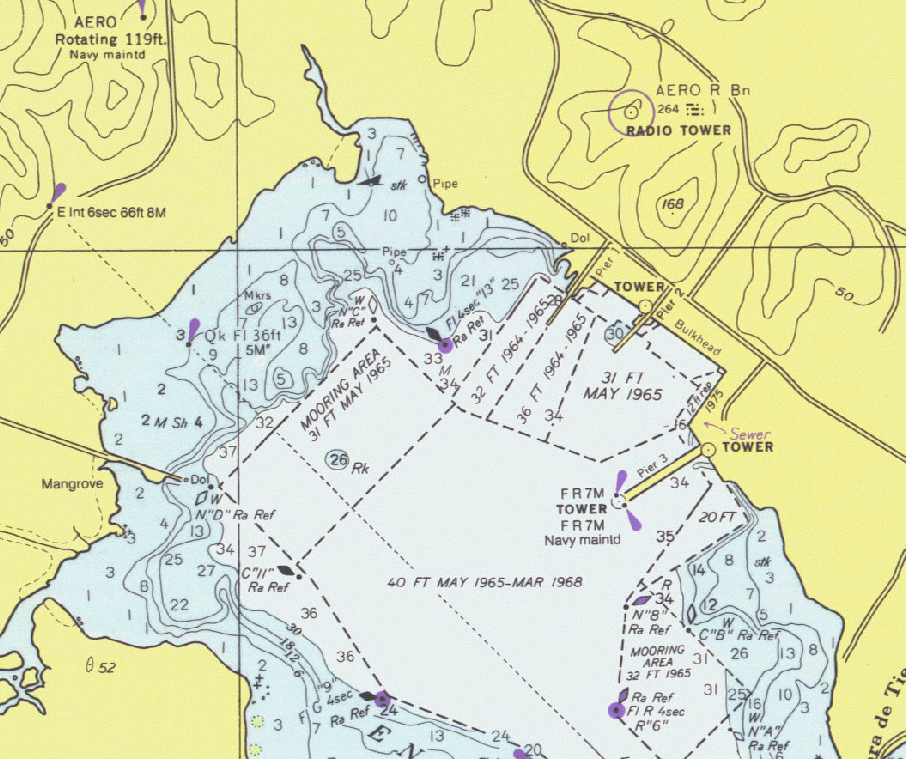
 |
A 1976 United States NOAA chart of part of Puerto Rico
|
A nautical chart is a graphic representation of a maritime area and adjacent coastal regions. Depending on the scale of the chart, it may show depths of water and heights of land (topographic map), natural features of the seabed, details of the coastline, navigational hazards, locations of natural and human-made aids to navigation, information on tides and currents, local details of the Earth's magnetic field, and human-made structures such as harbours, buildings and bridges. Nautical charts are essential tools for marine navigation; many countries require vessels, especially commercial ships, to carry them. Nautical charting may take the form of charts printed on paper or computerized electronic navigational charts. Recent technologies have made available paper charts which are printed "on demand" with cartographic data that has been downloaded to the commercial printing company as recently as the night before printing. With each daily download, critical data such as Local Notice to Mariners is added to the on-demand chart files so that these charts will be up to date at the time of printing.
Sources and Publication of Nautical Charts
Nautical charts are based on hydrographic surveys. As surveying is laborious and time-consuming, hydrographic data for many areas of sea may be dated and not always reliable. Depths are measured in a variety of ways. Historically the sounding line was used. In modern times, echo sounding is used for measuring the seabed in the open sea. When measuring the safe depth of water over an entire obstruction, such as a shipwreck, the minimum depth is checked by sweeping the area with a length of horizontal wire. This ensures that difficult to find projections, such as masts, do not present a danger to vessels navigating over the obstruction.
Nautical charts are issued by power the national hydrographic offices in many countries. These charts are considered "official" in contrast to those made by commercial publishers. Many hydrographic offices provide regular, sometimes weekly, manual updates of their charts through their sales agents. Individual hydrographic offices produce national chart series and international chart series. Coordinated by the International Hydrographic Organization, the international chart series is a worldwide system of charts ("INT" chart series), which is being developed with the goal of unifying as many chart systems as possible.
There are also commercially published charts, some of which may carry additional information of particular interest, e.g. for yacht skippers.
Chart Correction
The nature of a waterway depicted by a chart may change, and artificial aids to navigation may be altered at short notice. Therefore, old or uncorrected charts should never be used for navigation. Every producer of nautical charts also provides a system to inform mariners of changes that affect the chart. In the United States, chart corrections and notifications of new editions are provided by various governmental agencies by way of Notice to Mariners, Local Notice to Mariners, Summary of Corrections, and Broadcast Notice to Mariners. In the U.S., NOAA also has a printing partner who prints the "POD" (print on demand) NOAA charts, and they contain the very latest corrections and notifications at the time of printing. To notice to mariners, Radio broadcasts give advance notice of urgent corrections.
A good way to keep track of corrections is with a Chart and Publication Correction Record Card system. Using this system, the navigator does not immediately update every chart in the portfolio when a new Notice to Mariners arrives, instead creating a card for every chart and noting the correction on this card. When the time comes to use the chart, he pulls the chart and chart's card, and makes the indicated corrections on the chart. This system ensures that every chart is properly corrected prior to use. A prudent mariner should obtain a new chart if he or she has not kept track of corrections and his chart is more than several months old.
Various Digital Notices to Mariners systems are available on the market such as Digitrace, Voyager, or ChartCo, to correct British Admiralty charts as well as NOAA charts. These systems provides only vessels relevant corrections via e-mail or web downloads reducing time needed to sort our correction for each chart. Also, tracings to assist corrections are provided at the same time.
The Canadian Coast Guard also produces the Notice to Mariners publication which informs mariners of important navigational safety matters affecting Canadian Waters. This electronic publication is published on a monthly basis and can be downloaded from the Notices to Mariners (NOTMAR) Web site. The information in the Notice to Mariners is formatted to simplify the correction of paper charts and navigational publications.
Various and diverse methods exist for the correction of electronic navigational charts.
Limitations
In 1973 the cargo ship MV Muirfield (a merchant vessel named after Muirfield, Scotland) struck an unknown object in waters charted at a depth of greater than 5,000 metres (16,404 ft), resulting in extensive damage to her keel. In 1983, HMAS Moresby, a Royal Australian Navy survey ship, surveyed the area where Muirfield was damaged, and charted in detail a previously unsuspected hazard to navigation, the Muirfield Seamount.
The dramatic accidental discovery of the Muirfield Seamount is often cited as an example of limitations in the vertical geodetic datum accuracy of some offshore areas as represented on nautical charts, especially on small-scale charts. A similar incident involving a passenger ship occurred in 1992 when the Cunard liner Queen Elizabeth 2 struck a submerged rock off Block Island in the Atlantic Ocean. More recently, in 2005 the submarine USS San Francisco (SSN-711) ran into an uncharted sea mount about 560 kilometres (350 statute miles) south of Guam at a speed of 35 knots (40.3 mph; 64.8 km/h), sustaining serious damage and killing one seaman. In September 2006 the jack-up barge Octopus ran aground on an uncharted sea mount within the Orkney Islands (United Kingdom) while being towed by the tug Harold. £1M worth of damage was caused to the barge and delayed work on the installation of a tidal energy generator prototype. As stated in the Mariners Handbook and subsequent accident report "No chart is infallible. Every chart is liable to be incomplete".
Map Projection, Positions, and Bearings
The Mercator projection is almost universally used in nautical charts. There are however some exceptions for very large or small scales where projections such as the gnomonic projection may be used. Since the Mercator projection is conformal, that is, bearings in the chart are identical to the corresponding angles in nature, bearings may be measured from the chart to be used at sea or plotted on the chart from measurements taken at sea.
Positions of places shown on the chart can be measured from the longitude and latitude scales on the borders of the chart, relative to a geodetic datum such as WGS 84.
A bearing is the angle between the line joining the two points of interest and the line from one of the points to the north, such as a ship’s course or a compass reading to a landmark. On nautical charts, the top of the chart is always true north, rather than magnetic north, towards which a compass points. Most charts include a compass rose depicting the variation between magnetic and true north.
Electronic and Paper Charts
Conventional nautical charts are printed on large sheets of paper at a variety of scales. Mariners will generally carry many charts to provide sufficient detail for the areas they might need to visit. Electronic navigational charts, which use computer software and electronic databases to provide navigation information, can augment or in some cases replace paper charts, though many mariners carry paper charts as a backup in case the electronic charting system fails.
Labeling Nautical Charts
Nautical charts must be labeled with navigational and depth information. There are a few software solutions in the market that do automatic label placement for any kind of map or chart.
Details on a Nautical Chart
Pilotage Information
 |
Detail of a United States NOAA chart, showing a harbour area
|
Colours distinguish between man-made features, dry land, sea bed that dries with the tide and seabed that is permanently underwater and indicate water depth.
Depths and Heights
Depths which have been measured are indicated by the numbers shown on the chart. Depths on charts published in most parts of the world use metres. Older charts, as well as those published by the United States government, may use feet or fathoms. Depth contour lines show the shape of underwater relief. Coloured areas of the sea emphasise shallow water and dangerous underwater obstructions. Depths are measured from the chart datum, which is related to the local sea level. The chart datum varies according to the standard used by each National Hydrographic Office.In general, the move is towards using Lowest Astronomical Tide (LAT), the lowest tide predicted in the full tidal cycle, but in non-tidal areas and some tidal areas Mean Sea Level (MSL) is used.
Heights e.g. a lighthouse, are generally given relative to Mean High Water Springs,(MHWS). Vertical clearances e.g. below a bridge or cable are given relative to Highest Astronomical Tide (HAT). The chart will indicate what datum is in use.
The use of HAT for heights, and LAT for depths, means that the mariner can quickly look at the chart to ensure that they have sufficient clearance to pass any obstruction, though they may have to calculate height of tide to ensure their safety.
Tidal Information
Tidal races and other strong currents have special chart symbols. Tidal flow information may be shown on charts using tidal diamonds, indicating the speed and bearing of the tidal flow during each hour of the tidal cycle.
See the original article:
Nautical Chart From Wikipedia, the free encyclopedia
No comments:
Post a Comment